The Windward Passage

Barahona, Dominican Republic

By: Kerry

This famously cantankerous, 80km-wide strait separates Cuba from Haiti (east-west), and the Atlantic Ocean from the Caribbean Sea (north-south). The prevailing easterly trade winds, blowing in straight off the Atlantic, can kick up big swells and make for a very uncomfortable voyage.

As it turned out, on our first day we raised sails and actually turned the engines off. But it wasn’t long before it got windy and lumpy and we were back to motoring into headwinds. The first night was the worst: on Damian and my watch we were battering into 25-28 knots, rough seas and waves hitting the stern were splashing us at the helm station amidships.

The two nights, three days and 567 nautical miles of the trip are a bit of a blur: it was rough and windy. Enough said. We aimed to stay in international waters in the middle of the strait – to starboard lay Cuba (we passed close to Guantanamo Bay) and to port lay Haiti (cruiser scuttlebutt mutters about pirates and recent assaults on yachties).

We had a brief respite from the wind one hot midday, when we found ourselves in a field of fish traps – plastic water bottle buoys all over the place – tended by lone fishermen in tiny wooden skiffs powered by huge amounts of sail area relative to their size: they reminded me of the old 18-foot skiffs that sail on Sydney Harbour.

The contrast between the skiffs and the multi-million dollar gin palaces we’d been surrounded by a week previously; between the one of the world’s richest nations and one of its poorest, couldn’t have been more extreme.

Haiti’s western coastline is shaped like a huge fish tail: we rounded its southern point and motored straight into the teeth of the trade winds along the coast of Haiti until we crossed the border into the Dominican Republic and dropped anchor off the beach at the first available port of entry, Isla Beata.

Fantazia Caribbean-8657

Isla Beata, Dominican Republic

Fantazia Caribbean-8655

Customs commandeered a local fishing boat to come and clear us in.

Next day saw the worst leg of the trip so far: it took us 10 hours to cover 56 miles to Barahona on the coast of the Dominican Republic ‘mainland’, with strong headwinds and a nasty chop that kept thumping up under the bridge deck hard enough to make your teeth rattle.

Just on 1000 miles since Florida…

~~~ ><(((°>  ><(((°> ><(((°> ~~~

Exploring the Exumas … Albeit Briefly.

Cape Santa Maria, Long Island, Exumas

By: Kerry

Fantazia Caribbean-8537We motored across dead calm water to the south-west side of Highbourne Cay – which lies about half-way down the 140 nautical mile chain of low, sandy islands making up the Exuma Cays – and anchored off a brilliantly white beach in just a couple of metres of swimming-pool-blue water: the colour and clarity is incredible.

The island is privately owned, but we were able to go in to the small marina – full of game fishing and charter boats – and fuel up. It reminded me of the BVIs: neat, clean and thoroughly sign-posted, with a small general store selling souvenirs and exorbitantly priced groceries.

Garth and I took the dinghy and circumnavigated the island, which is about three miles long. We stopped for a snorkel on the windward side at a spot recommended by the local dive operation. There were a few small but pretty fan corals and a few colourful fish, but nothing compared to what we’re used to in the Pacific.

We continued past the long white East beach (“world-renowned as one of the best beaches in the Bahamas”) that stretches the full east coast of the island, back to the marina, where a bunch of fat and happy nurse sharks were sunning themselves beneath the fish cleaning station, obviously waiting for an easy afternoon tea. They took no notice of us as we floated a metre above them in the dinghy – very tempted to jump in with them…

John had us up early the next day, headed for Warderick Wells, headquarters of the Exuma Cays Land and Sea Park. The cay shelters a sinuous channel flanked by sandbanks that dry at low tide to glaring white, sliding into a stunning wash of blues from palest pool to richest royal.

Established in 1958, the ECLSP extends for 22 miles from Wax Cay Cut in the north to Conch Cut in the south and about four nautical miles on either side of the cays.

I wanted to do some snorkelling, but the boys weren’t up for it after we were visited by a bunch of lazy nurse sharks who hung out around Fantazia’s transom, looking for a feed.

On Cherry, the Park Ranger’s recommendation, at slack tide (the current is too strong at any other time), I snorkelled on a coral garden in the channel. About the same area as Fantazia’s deck, the garden’s coral life was fairly limited but, hidden amongst it I saw a huge lobster; the biggest pair of angelfish I’ve ever seen; a lion fish; schools of blue tang and snapper and a grouper lurking beneath a ledge. It’s the greatest concentration of life I’ve seen so far: elsewhere the sea bottom has been bare sand – beautiful, but barren.

We also walked to the top of the ‘famous’ Booboo Hill, where yachties have been piling up planks of driftwood and palings adorned with their boat names for, it would appear, decades.

With the calendar and a possible change in the weather starting to work against us, we were off next morning to Staniel Cay, the cruising hub of the Exumas. Initially, we were going to go into the Staniel Cay Marina, but our ‘berth’ turned out to be un-negotiable, thanks in part to a stiff breeze and a four-knot current blasting past the pilings, so we anchored off instead.

It would have been nice to spend a day or so looking around (I really wanted to meet the famous swimming pigs) but, as it was, we had a quick wander, picked up a few supplies from the pink market and the blue market and had time to sample a few rather wicked rum punches in the bar by the dock…

And then we were off again, heading out through Galliot Cut into the Exuma Sound, and open Atlantic Ocean for the run down the back side of the Cays, re-entering via Conch Cay Cut to Elizabeth Harbour, between Stocking Island and Great Exuma Island.

Sand Dollar Beach on Stocking Island was crowded with a couple of hundred cruising yachts – by far the most we’ve seen so far – apparently many spend the whole winter here, and there’s a beach bar; a shack selling conch fritters; volleyball nets and the familiar totem pole of sign posts to visitors’ home ports.

Across the harbour, George Town is ostensibly the ‘capital’ of the Exumas. It’s charming in a sprawling, dusty, colourful Caribbean way: pretty much everything is arranged around Lake Victoria – a circular inlet accessed by dinghy through a narrow cut from Elizabeth harbour. Backing on to the Lake is Exuma Markets – the first supermarket we’ve found since Florida, with pretty much anything you’d want.

There’s also a straw market where a bunch of languid local women make and sell baskets, shell jewellery and t-shirts; an impressive, peach-painted Georgian-style administration building; a few cafes; and a bunch of dread-locked locals sitting on a wall in the main street, doing nothing much.

We had to pick our way pretty carefully between the reefs to get out into open water, and actually got a sail up for a change, and had a nice sail to Cape Santa Maria on Long Island: our launch pad for the Windward Passage.

370 nautical miles since Florida…

~~~ ><(((°>  ><(((°> ><(((°> ~~~

Bahamas Bound

Exumas, Bahamas

By: Kerry

Fantazia Caribbean1-8427We’re sailing through the Bahamas – actually the Exumas, the chain of little island jewels to the east of Nassau, to be precise – on a clear-sky, no-wind day, eating freshly barbecued crayfish and swigging chilled pinot grigio. And it’s only our second day out.

Fantazia, the boat we’re on, is a 55-foot catamaran, similar to ours, owned by our friend John Woodruff. He’s shipped it (yes, put his boat on a ship) from Brisbane to Fort Lauderdale as the starting point for an adventure that will see him sail from the east coast of the US, through the Caribbean and Panama into the Pacific and, eventually, back to Australia. He’s very kindly asked us (Damian, me, Garth and Mick) along for the first stage of the trip, to help him sail the boat from Fort Lauderdale, Florida to Antigua in the Caribbean.

The transporter ship arrived loaded with a dozen or so boats, ranging from smaller cruising yachts up to 60-metre super yachts. It’s remarkable in that all the ‘cargo’ boards the ship on its own bottom: the entire ship sinks to a depth of five metres; the cargo deck floods and all the boats motor on board, where steel supports are individually welded in place by a team of divers. The ship then re-surfaces, the cargo is raised high and dry, and off it goes.

We (very gladly) left Fort Lauderdale after 10 days of humidity, ferocious no-see-ums (sand flies) and a false start thanks to fuel filter issues, that saw us return to port for an extra night.

Problems fixed, we headed out of the Intracoastal canal system and turned south – passing the towering high-rises along the Miami beaches – hugging the coast to stay inside the four-knot south-north Gulf Stream current, which will push us northward 2.5 miles for every hour we’re at sea. Then we headed east, motoring hard across the current as it took us easterly on a diagonal track towards the Bahamas.

This 130nm passage to the clearance port of Chub Cay can be pretty unpleasant if the wind decides to contradict the tide and current.

A local cruising guidebook describes the Gulf Stream off Florida as “…a 45-mile wide river, more powerful than you can imagine. You can’t see the speed of its wash like standing on a river bank, but it is there, flowing northward at an average speed of 2.5 knots, day and night, in every season.”

When you get a ‘norther’ blowing, the sea horizon is often ‘jagged and saw-toothed’. “That,” says the guide, “Is when there are ‘elephants’ out there; giant square waves…kicked up by the Stream’s determination to win its way north against the wind, come what may.”

After all the holdups, we managed to sync our passage with a forecast for calm seas and light winds. We motored into a soft evening and a clear warm night: we’re back in the tropics!

We crossed onto the Great Bahama Bank – the broad, shallow plateau that backs the leeward side of the islands of the Bahamas and the depth went from 300 metres to three. At around 2:00 am we stopped and dropped anchor – not in a safe harbour, but in the middle of nowhere…

I woke to a silent, beautiful dawn: swirls of watercolour clouds reflected in a seamless bubble encompassing horizon-less ocean in every direction. It was the weirdest feeling: I’ve spent many days surrounded by 360 degrees of sea, but I’d never anchored in the middle of the ocean before – nor anchored in three metres of water out of sight of land.

As the sun rose, we weighed anchor and motored for Chub Cay, docking in the small marina by mid-afternoon.

Chub Cay typifies the boom and bust history of the Bahamas: a dozen gelato-coloured, Hamptons-style, two-storey condos with massive, twin air conditioning compressors plumbed in like artificial lungs, stand empty. A white wedding cake of a building that at first glance looked complete, but on closer inspection had electrical wires hanging out of the walls, also appeared abandoned. The place felt dead: flattened and bleached by the relentless, breathless heat.

John went to the airport to clear Customs, while the rest of us went to the perfectly clean, wet-edge pool attached to the abandoned wedding cake and spent the rest of the afternoon chilling.

We went for dinner at the Marina restaurant, where the bar was full of Floridian game fishermen, looking for Ernest Hemingway in the bottom of their Heinekin bottles. There were some black and white photos on the walls from the sixties, of enormous marlin flanked by the triumphant fisherman and his other trophy, the long-legged wife in short shorts and matching mules.

The timing of our trip down the Exumas is tied to weather and tides: the tidal range is only a metre, but it creates fierce currents through the passes between the cays, so passages have to be planned to coincide with slack water.

Hence, we left Chub Cay in the almost-still-dark. Dark enough that we nearly hit the sea wall of the marina on the way out… So much for ‘eyeballing’ the route!

The previous afternoon, Mick managed to acquire a dozen crayfish tails for US$70 from a local fisherman in Chub Cay: the dude was sorting through a tall bucket full of tails, about half of which appeared to be undersized.

And so, as we motor across what feels like the centre-page spread of the Bahamas tourism brochure, we fire up the Webber, I knock up a cheeky little lime butter dressing and we gorge on mouth-watering fresh crayfish: jus gettin’ in de swing of t’ings, mon.

~~~ ><(((°>  ><(((°> ><(((°> ~~~

A Short Sojourn in Sydney and Sussex

Fort Lauderdale, Florida

Sydney sojourn-8340We left Sel Citron tucked into a marina berth in Gulf Harbour, New Zealand in early February and headed back to Sydney, ostensibly en route to Fort Lauderdale, but also to catch up with friends, family… and so that Damian could get a nose job.

He was thinking something pert and upturned, but the doctor wasn’t up for it. In fact, it was more about function than form: he has had a deviated septum forever, which causes him all sorts of trouble – like, he can’t breathe. He’s been putting off the op for a couple of years, but it was time…

So he had the op – and it all went well – and he went into hibernation for a week as he felt too crappy to see anyone (thanks, Tanya and Mick, for the offer of a recuperation ‘cave’ and apologies to everyone he didn’t get to see!) while I ran around seeing everyone I could and spending some time with my family (thanks Hunters for use of your front room!).

Damian’s Dad lives in West Sussex and turns 80 in June. It’s not likely he’ll be able to get out to Sel Citron, so as a surprise, Damian flew to the UK and turned up in time for dinner. He then took Rob (his Dad) on a boys’ road trip to the south of France, to the Catana factory, where Sel Citron was built. They were able to look over a sister ship to Sel Citron (only 18 were built, so it was a fortunate coincidence that one was there on the dock) and see the new Catana 59 and do a factory tour.

They had a great time and, while in England, Damian also got to spend time with the rest of his family and to meet his new nephew, Harry, who was born in January. (Congratulations Bex and Karl!).

He then flew on to Florida and spent a weekend with his old work mate, Gary and his wife, Lynie.

Meanwhile, I did my own, solo road trip up to Queensland, arriving in time for floods – and a touch of déjà vu – to go and play with my cuzzy-bros and besties up there – thanks to Lee and Bill; Al and Ian; Nod and Ray and my ‘children’; Chrissie and Pete; Jules and Angelika; the Downey clan; and Max and Judie for putting me up and putting up with me!

I drove back to SYD for a last few frenzied days (thanks Pete and Gwyn, and Elaine, hostess with the mostess, for my sleepovers) then jumped on a plane and met Damian in Fort Lauderdale, Florida, for the next adventure…

~~~ ><(((°>  ><(((°> ><(((°> ~~~

Tackling the Tongariro Alpine Crossing

Fairway Bay, Gulf Harbour

By: Kerry

Tongariro Crossing1-4480Hiking (or ‘tramping’) in New Zealand is primarily associated with the famous trails of the South Island. But right in the centre of the North Island, three hours drive south of Auckland, is a region of active volcanoes that provides the dramatic setting for New Zealand’s best one-day hike: the Tongariro Alpine Crossing.

The rocky and often steep track traverses active volcanic craters, rises to nearly 2000 metres and skirts surreally-hued crater lakes that shimmer with steam – and freeze over in winter.  The alpine weather can change in minutes from brilliant sunshine to icy sleet and there are no supplies available en route. It can be completed in a day, but Lonely Planet describes it as ‘exhausting’.

We drove down from Auckland and met up with the Kiapas and Maunies in the little village of National Park, where we’d booked a cottage for three nights to give us some flexibility with the weather: you really don’t want to tackle Tongariro in crappy weather.

The Tongariro National Park encompasses three active volcanoes that lie along the string of volcanoes ridging the North Island’s Central Plateau. The highest is Mt Ruapehu, at 2797 metres. On our first morning, Ruapehu was invisible in thick cloud: with a better forecast for the following day, we went mountain biking rather than hike the Crossing in freezing fog.

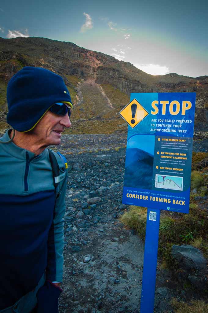
There’s no cost to do the walk – the trail, boardwalks, signage and amenities are immaculately maintained by the Department of Conservation – which in part explains why up to 1000 people hike the trail each day.

We were keen to get a jump on the crowds – most of whom are reliant on a public transfer from town. The guy from the bike shop gave us the tip: be on the trail by dawn. The only way to do that is with your own vehicle. So we’d parked one car at the end of the trail the previous night, and drove to the start of the trail in pre-dawn chill. It worked though: we were the first out of the blocks.

The track starts at 1100 metres above sea level and soon starts winding upwards, following the Mangatepopo Valley. We were in deep, cold shade, trekking in beanies, gloves and thermals – but it wasn’t long before we were peeling off the layers.

Tongariro Crossing-4497Despite the dire danger warnings posted everywhere from the park signboards to the Lonely Planet guide book urging trampers to check they are properly prepared for this challenging walk (make sure you have enough water, stout walking boots, thermals, wet weather gear and adequate fitness), we were soon being overtaken by a motley collection of backpackers doing the walk seemingly woefully under-prepared.

Lucky for everyone, the weather was perfect: with glorious sunshine and no wind, as the day wore on, the exposure threat was more from heat stroke than hypothermia.

From the top of the first climb, there are endless views to the south, including of volcanic Mt Taranaki. It’s then a flat, exposed stretch through the broad glacial basin known as the South Crater. The only obvious sign of life is the sparse clumps of tussock grasses scrabbling a living between monster blocks of rock that erupted – possibly recently – from the volcanoes flanking the valley.

The very recent and reasonably violent volcanic activity in the Park adds a unique frisson to the walk. Mt Ruapehu erupted in 1995, 1996 and again in 2007. Tongariro erupted as recently as 2012, vaulting 20,000 volcanic ‘bombs’ into the sky, one of which – a large boulder – smashed through the roof of the Ketetahi hut, used by hikers as an overnight stop on the trail. Signs and signal lights all along the trail warn that the entire area remains “in a heightened state of unrest and eruptions can occur at any time”.

We walked past Mt Ngauruhoe, which featured as Mt Doom in the Lord of the Rings movies. It didn’t exist at all until about 7000 years ago and last erupted in 1975. We opted out of the optional side trip to climb its scree-covered slopes to the summit at 2287m…

From the South Crater, the track winds upwards, skirting Mt Tongariro (another potential side trip, to the summit at 1967m) to the high point of the Crossing at Red Crater, at 1886 metres.

As I panted up the final approach, a skinny German backpacker in baggy t-shirt, shorts and Converse sneakers came towards me, walking in the opposite direction against the flow of trekkers, playing a ukulele and singing, sotto voce, the Johnny Cash anthem, “Burning Ring of Fire”.

How appropriate.

The Red Crater is around 10,000 years old with a hollow lava tube (aka a dike) in its middle that has a remarkably ‘labial’ look about it (thanks, Lionel, for pointing that out – once you see it, you can’t forget it).

The views to the other side take in the absurdly lurid Emerald Lakes – explosion craters that have filled with mineral-laden water – set like cabochons of turquoise in the red-brown landscape, and volcanic vents and fumeroles sending up plumes of steam. From the saddle, the trail descends steeply down a slippery scree slope that has just about everyone landing on their bum at some point, to the shores of the Emerald lakes.

We stopped for lunch in the lee of a huge boulder on the edge of an elyptical lake that looked like it had been painted in the pure hues of the printer’s palette: cyan water, magenta grasses around the edges, and sulphurous yellow and black rocks looming over it and mirrored in its surface.

Even though the sun was shining, the altitude made it too cold to stop for long and we headed off towards the Blue Crater. Looking back along the track from the rim gives a wide-angle view of the broad black lava floes, red oxide-stained volcanic cones and the barren, chocolate-coloured scree slopes we’d negotiated throughout the morning.

Just beyond the crater lake, we had our first views to the north, all the way to Lake Taupo, before the track began to zig zag down in an extraordinary series of broad switchbacks that make things very easy on the knees – it became suddenly evident why it’s recommended to walk in the direction we’d taken. It would be punishingly demoralising to start the walk in the other direction and spend hours walking up the hill.

We wound our way down through scrub and bushland and native forest and emerged at the car park.

They say the trail takes six to eight hours. We did it in nine and a half, but we took it easy, and had lots of snack and photo stops. Rather pleasingly, we pulled up pretty well – not even a blister or a sore muscle!

Nevertheless, we felt very relieved (and ever so slightly smug, as we passed pooped trekkers waiting for their transfers) that we could pile into the crew car and head off (still in our hiking gear) for high tea at the Whakapapa Chateau.

So very civilised, Dahling!

PS> Damian took some great photos on the day – see the album of his photos on the Images page.

 ~~~ ><(((°>  ><(((°> ><(((°> ~~~

Walking and Wining on Waiheke

Waiheke Island, Hauraki Gulf, New Zealand

By: Kerry

Walking on Waiheke-1600 Waiheke Island – 45 minutes by ferry from downtown Auckland in the Hauraki Gulf – is known for its boutique wineries. But even better than its fine wines is the network of 100 or so kilometres of walking trails, collectively known as Te Ara Huru. We spent January cruising the Hauraki Gulf islands, with much of our time on Waiheke. We covered most of the western half of the island’s walking tracks, in addition to the Stoney Batter walk (on the far eastern side) on New Years Day.

The Stoney Batter Walk, New Years Day

Our favourite was the Headlands walk, starting from the little township of Oneroa and tracking along the cliff edges and beaches of the north-east and western coasts. Each climb to a high point revealed astonishing views across the island and the Gulf: craggy black cliffs sprouting huge, gnarled, scarlet-flowering Pohutakawa trees, and rocky islands dotted across sparkling, tropical-hued water stretching all the way to the Auckland city skyline.

The Headlands Walk, Waiheke Island

And on every cliff top, there was at least one example of the Kiwi penchant for choosing the most spectacular but inaccessible building site and constructing a formidable and extravagant architectural statement – apparently some of these massive ‘piles’ sell for upwards of $15 million. The track winds up and down to pretty beaches and secluded coves (in one of which I discovered my dream home – a modest ‘pile’ by comparison, with its own private pebble beach sheltered within a tiny cove and with a perfect northerly aspect), skirts around vineyards and, on the homeward leg, passes a few cellar doors where a crisp glass of pino gris does wonders to restore one’s energy levels.

My future view-from-the-front door...

My future view-from-the-front door…

When my friend Elaine came to stay for a few days, the biennial Headlands Sculpture Exhibition was strung along the walking track, with some whimsical and impressive artworks. In her inimitable style, Elaine also shouted us to a delicious lunch and wine tasting at the Mudbrick Winery. But we made the mistake of mis-judging the tide: when we got back to Oneroa, our dinghy was high and dry and wasn’t going to float for another hour or so. Just as well Elaine had bought a bottle of spark en route!

Hunter-gathering was high on the agenda as we pootled around the Gulf islands with the Kiapas. We caught a few fish, and even a couple of crayfish, but the highlight was diving for scallops. Lionel, Irene and I would dive (tanks and full wetsuits, including hoods – the water’s not quite tropical temp) while Damian manned the dinghy. It took a little while to get your eye in, but once you did, it was fairly easy to spot the shallow indentation in the sand marking the outline of the buried scallop. We managed to catch our quota (20 per person, minimum 10cm diameter) in about 10 metres of water on less than half a tank of air. Walking on Waiheke-7795

And oh, were they ever sweet and succulent – the most delicious seafood I’ve ever tasted.

After all the evil weather we’ve endured over the winters here, we had a whole month of perfect sunny days – who knew Inzud could turn on weather like it? We climbed Rangitoto (the perfectly symmetrical, dormant volcano that can be seen from anywhere in the Gulf); met the peacocks on Kawau Island and the myriad little birds (including the tuis) on the sanctuary of Tiritiri Matangi; hiked on Motutapu and Ponui and dived on Rakino.

Finally, after two and a half years of being NZ-based, we’ve been able to really enjoy cruising in New Zealand. We’ve only seen the Hauraki Gulf, and there is so much more to see, but even so, we rate it as some of the best cruising we’ve done anywhere in the world.

Oneroa beach, Waiheke

Oneroa beach, Waiheke

~~~ ><(((°>  ><(((°> ><(((°> ~~~

Happy New Year!

Waiheke Island, New Zealand.

By: Kerry

We are anchored in Man o’ War Bay, Waiheke Island, in the Hauraki Gulf. It’s calm, sunny and very, very beautiful. We were here for NYE and – much to our surprise and delight – there were no dragged anchors, drunken fools, or badly behaved yobs, despite the wind swinging 180 degrees soon after midnight, with the potential to cause complete chaos. In fact, we were the last boat to bed at around 2.30. We had friends on board for drinks and a BBQ and a bevvie or three. A really fun evening.

And we shaped up well enough to do a hike today to Stoney Batter on the NE tip of the island – stunning scenery and the Pohutakawa trees are all covered in crimson flowers!

Christmas 2014-1603Plans from here are… vague. We’ll hang around here a few more days – the sun is shining (though the water’s too chilly for my liking!) and the fish are biting.

Christmas 2014-7590In case you were wondering, we managed to hook a couple more snapper on Christmas morning, just in time for five of us to have one each for lunch! Yummo.

~~~ ><(((°>  ><(((°> ><(((°> ~~~